
Scarce Precipitation Leads to Widespread Drought Degradation
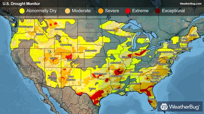
Precipitation was scarce across large portions of the nation this week, with many areas receiving less than 25 percent of normal precipitation. Widespread degradation occurred as a result, though some areas saw targeted improvements.
Northeast
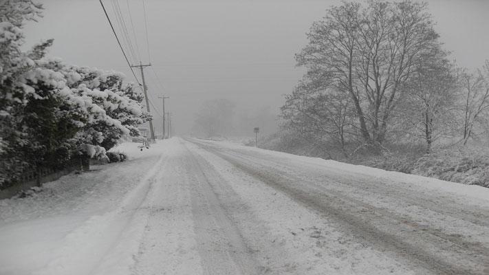
A large upper-level weather system was stalled over the Eastern U.S. for much of this week, allowing quicker clipper-type systems to move across the region. Lake-effect areas saw almost daily chances for snow, while little precipitation occurred elsewhere. Temperatures also remained cold and below the normal for this time of year. Given the cold temperatures and limited frozen precipitation, much of the Northeast remained unchanged despite streamflows remaining below average and low soil moisture.
However, long-term indicators supported several targeted improvements to abnormal dryness and moderate drought (D0-D1) in New York, where precipitation deficits and groundwater conditions showed gradual recovery. Severe drought (D2) was also removed from east-central Pennsylvania and northeastern New Jersey.
Southeast
Overall, it was a chilly but mostly dry week of weather throughout the Southeast. Though, some areas continue to benefit from moisture that fell earlier this winter. A winter storm did bring well above normal precipitation to the coastal Carolinas, much of it falling as snow. The combination of frozen precipitation and cold temperatures limited the immediate hydrologic benefit, leaving most of the reason unchanged.
Across the central Gulf Coast region, extending from southern Alabama through southern Georgia and into northern Florida, conditions continued to deteriorate following another week without precipitation. Growing precipitation deficits, very low streamflows, declining soil moisture and increasing fire also supported degradation across the areas. Extreme drought (D3) from southern Georgia into northern Florida broadly expanded farther south across the Florida Peninsula. Extreme drought (D3) was also introduced to west-central Florida just southeast of Tampa as well as the southern Everglades region. Moderate drought (D1) also increased in coverage across southeastern Virginia.
Conversely, there were slight improvements to the drought depiction in west-central Alabama. Here, both moderate and severe drought (D1-D2) contracted slightly.
South
Drought conditions across the South generally continued to worsen this week as much of the region received little to no precipitation. Temperatures were also near to slightly above normal. There were a few localized improvements from last week’s storm, where severe drought (D2) decreased slightly in northeastern Louisiana and abnormal dryness contracted in southeastern Mississippi. Otherwise, conditions continue to degrade across most of the region.
Across the southern Plains into the Lower Mississippi Valley, one-category degradations were seen across parts of northeast/eastern Texas, northern/southwestern Oklahoma, much of Arkansas, central/southeastern Louisiana and southwestern Mississippi. Small areas of extreme drought (D3) were introduced in southwestern Louisiana and eastern Texas. Meanwhile, extreme drought (D3) also expanded across northern Arkansas and central Texas.
Midwest
Outside of a few localized improvements, cold temperatures and limited frozen precipitation led to persistent conditions across much of the Midwest. Cold conditions kept soils frozen across northern portions of the Midwest, limiting infiltration and preventing recent moisture or snowmelt from entering the hydrologic systems. As a result, short-term improvements to soil moisture and streamflows.
Western Michigan saw localized improvements, where another week of snowfall along the Lake Michigan shoreline, combined with improving longer-term precipitation indicators, supported modest recovery.
Across parts of the western and central Midwest, minor degradations were introduced as conditions continued to dry, including the introduction of extreme drought (D3) in southwest Missouri along the Missouri-Oklahoma border. Moderate drought (D1) also expanded across central and southeastern Illinois, while abnormal dryness increased in central Iowa.
High Plains
Conditions across the central and northern High Plains were mostly unchanged this week, as most of the region received little to no meaningful precipitation. Cold temperatures persisted, and where snow did fall, it remained largely frozen in place, limiting short-term benefits to soils or hydrologic conditions.
Conditions across the Wyoming and Colorado Plains continued to deteriorate. Snow water equivalent (SWE) remains well below average, with data showing values generally in the 50 to 70 percent of median range, reflecting how snowpack continues to fall short for this time of year despite recent snowfall.
Extreme drought (D3) increased in central Colorado, while severe drought (D2) expanded from southeastern Wyoming into northeastern Colorado and a little into the Nebraska Panhandle. Moderate drought (D1) expanded across much of eastern Wyoming and parts of northeastern Colorado. Abnormal dryness (D0) and moderate drought (D1) also expanded across portions of Kansas.
West
Across much of the western U.S., drought conditions worsened as a deepening snow drought, limited precipitation, and above-normal temperatures continued to suppress snowpack development. Although some mountain snowfall occurred, totals were generally modest and failed to keep pace with typical early February accumulation, leading to expanding snowpack deficits across the region.
Conditions intensified in the Intermountain West, where snow accumulation remains far below seasonal expectations. Many sites reported snow water equivalent (SWE) below the 15th percentile, with some at record-low levels for early February. These deficits were compounded by limited recent precipitation, declining soil moisture, and below normal streamflows across northern Idaho, Montana, Wyoming, Colorado and Utah.
Elsewhere, persistent warmth and dryness led to the expansion of drought conditions across southwestern Idaho, northern Nevada, eastern Oregon, and along the Pacific Coast, including southern Washington and northwestern California. Poor low-elevation snowpack, very low streamflows, and limited soil moisture recovery drove worsening conditions, while the only notable improvement in the West occurred in southern New Mexico, where earlier precipitation supported localized hydrologic recovery and reduced drought severity.
Looking Ahead
Over the next five to seven days, an active weather pattern is expected across much of the continental U.S., bringing significant precipitation to several regions. The heaviest amounts are forecast from the lower Mississippi Valley into the Ohio and Tennessee valleys, where widespread totals of 1 to 3 inches are expected, with locally higher amounts possible. The central Plains, Midwest, and Great Lakes are also likely to see moderate precipitation, generally ranging from 0.5 to 1.5 inches.
Across the West, precipitation is expected to be widespread from the Pacific Northwest into the northern and central Rockies, with liquid-equivalent totals of 1 to 3 inches in the Cascades and northern Rockies, especially at higher elevations. Farther south into the Great Basin and Southwest, precipitation becomes more limited and scattered, with most areas receiving less than 0.5 inches and many locations remaining dry.
Drier conditions are expected to persist across California, the northern Great Plains, central and southern Texas, and much of the Florida Peninsula, where little to no precipitation is forecast during the next week.
-----
Source: U.S. Drought Monitor