Severe Storms Rattle Texas to New York
This week’s stretch of severe weather will extend from the eastern Great Lakes to southern Texas today, putting tens of millions at risk.
As the storm tracks quickly eastward through the Great Lakes, anomalously warm air will be drawn north, boosting instability ahead of a sharp cold front draped from the eastern Great Lakes through the Mid-South. This environment will fuel widespread thunderstorms, some of which will quickly become severe.
The cold front will primarily support squall lines and clusters of thunderstorms capable of producing damaging winds, hail, and a few tornadoes from the eastern Great Lakes through the Ohio Valley and into the Mid-South. Severe impacts will linger through the evening across the Deep Mid-South. The greatest tornado potential will be focused across the Upper Ohio Valley, though isolated damaging wind gusts and hail will be possible throughout the region.
Farther southwest near the tail end of the front in Texas, isolated, short-lived supercells may develop and ripple eastward through the evening. These storms pose the highest threat for large hail and locally damaging winds. While the tornado risk in Texas remains low, an isolated tornado or two cannot be fully ruled out. Among the strongest storms, hailstones may reach or even exceed tennis ball size.
These storms could also produce locally heavy rainfall, with the heaviest rain concentrated in the Mid-South. Rain totals of 1 to 2 inches are expected through the weekend, with locally higher amounts up to 3 inches possible.
A Severe Thunderstorm Watch has been issued for northeast Louisiana and central Mississippi. Cities include Jackson, Greenwood, Hattiesburg, and Meridian, Miss.
Another Severe Thunderstorm Watch has been issued for south-central Texas. Cities include Cotulla, Laredo, Corpus Christi, Hondo, San Antonio, Victoria, and Palacios, Texas.
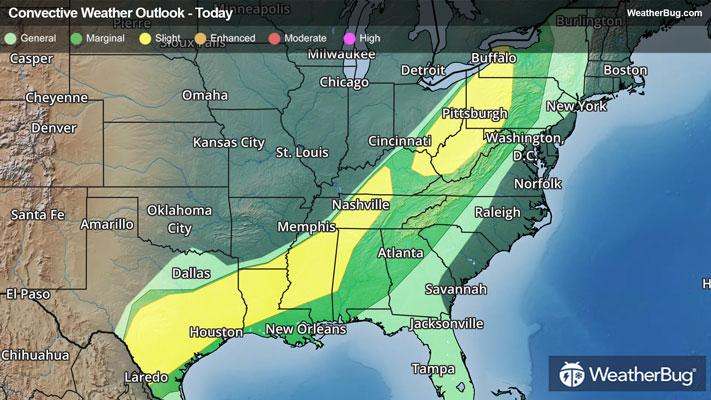
According to the Storm Prediction Center, there are two separate regions holding a Slight Risk (a 2 out of 5 on the severity scale) for severe weather. The first area is posted from eastern Kentucky through western New York, which holds a heightened risk for tornadoes, while the second is posted from western Kentucky through southern Texas, which holds a heightened risk for large hail. Both will also likely see scattered reports of damaging winds. There is also a larger Marginal Risk (a 1 out of 5 on the severity scale) encompassing these two greater risks from Lake Ontario and eastern Michigan through the Texas-Mexico border and much of the Deep South.
Cities affected under the Slight Risks include Houston, Dallas, and San Antonio, Texas, Shreveport, La., Jackson, Miss., Nashville, Tenn., Charleston, W. Va., Cleveland and Columbus, Ohio, Buffalo, N.Y., and Pittsburgh.
Previously under this system, two tornadic severe thunderstorms spawned on Friday. One of these produced a long-tracked, destructive, and ultimately deadly tornado in southwestern Michigan, impacting the communities of Three Rivers and Union City. Large hail reports were also clustered tightly under severe storms in eastern Nebraska and western Iowa, with hailstone diameters of up to 1.5 inches observed.
Make sure to know the difference between a watch and a warning should they be issued. A “watch” means that conditions are favorable for severe weather to occur, and to be on alert for any rapidly changing conditions. A “warning” means that severe weather is imminent, and you should act fast to remain safe.
The best way to remain safe is to stay prepared and informed about your local weather. Have a severe weather kit packed with a battery-operated radio, water, and non-perishable food items. Also, check the WeatherBug app frequently for any updates on today's severe weather. Remember, "When Thunder Roars, Go Indoors!”