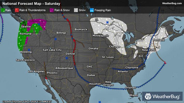
Friday's Weather Outlook

A snow-filled clipper system is set to sweep through the Great Lakes, Ohio Valley, and Mid-Atlantic.
The nonstop winter for the Ohio Valley and Great Lakes continues with another clipper system moving through. Diving out of Canada, this clipper will bring light snowfall accumulations to Michigan, Indiana, Ohio, eastern Kentucky, and West Virginia. The Mid-Atlantic will also be brushed up with snow with western sections of Pennsylvania, Virginia, and Maryland seeing snowfall. The high terrain of the Appalachians in West Virginia may see over 6 inches of snowfall.
Further to the south, rain/snow showers will be prevalent for central to eastern Virginia, eastern Tennessee, and North Carolina. However, no snow accumulation is anticipated.
Late into the night, more snow showers will move into western New York with a few inches of snow possible on top of an already impressive snowpack. The rest of the Northeast will be dry and chilly.
An impressive high-pressure system continues to stall and meander over the Western U.S. This is beginning to extend further to the east into much of the Central and Southeast U.S. with dry weather anticipated in the Southeast, Mid-South, Deep South, and the Plains.
Uneventful weather is in store once again for the Four Corners, Rocky Mountains, Great Basin, Pacific Northwest, and Desert Southwest. The northern and central West Coast will be dry, but a couple of light rain showers will occur for southern California. The highest elevations of the southern Sierra Nevada may see light snow out of this activity.
Single digits, teens and 20s will be grouped together in the Upper Midwest, eastern portions of the northern Plains, northern Mid-Atlantic, and Northeast. The southern Sierra Nevada mountains, southern Mid-Atlantic, Ohio Valley, and Lower Midwest can anticipate 30s and 40s. Forties and 50s will be likely for the western portions of the northern Plains, central Plains, Great Basin, Four Corners, Rocky Mountains, Pacific Northwest, and Southeast.
Fifties and 60s are expected for all the West Coast, Deep South, Mid-South, and Florida. The warmest air in the contiguous U.S. will reside in the southern Plains and Desert Southwest.
