
Back to Active Hurricanes
Erin Loses Tropical Characteristics Over Central Atlantic
August 22, 2025 at 06:17 PM EDT
UPDATED by WeatherBug Meteorologists
Hurricane Erin has lost its tropical characteristics, but remains a very powerful storm in the west-central Atlantic.
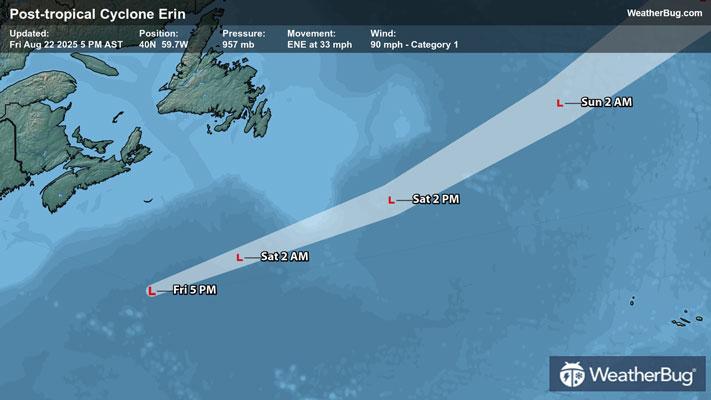
As of 5 p.m. AST/EDT, Hurricane Erin was located near 40.0 N and 59.7 W, or about 605 miles north-northeast of Bermuda, and 375 miles south-southeast of Halifax, N.S., in Canada. Despite no longer being tropical, Erin is still packing top winds of 90 mph. It is moving northeast at 33 mph and has a minimum central pressure of 957 mb, or 28.26 inches of mercury.
As Erin has been moving across the Atlantic, a warm and cold front have developed from the storm’s center. This is typically the last step in determining that a tropical storm is no longer tropical. That said, Erin’s impact on shipping interests remains quite high. Its strong winds are likely to whip the ocean to 20 to 40 foot wave heights.
Closer to shore, the book isn’t closed on Erin. The strong waves from the storm will likely cause rip currents throughout the weekend, making it dangerous to swim along the beaches of the Eastern Seaboard. High tide is likely to produce some coastal flooding, especially from the New Jersey shore to Maine.
Although Erin is now out of the picture, we are coming very close to the peak of the hurricane season. If you haven’t already, now is the time to prepare for the hurricane season. Have a “go” bag ready with chargers, water, food and other necessities. Also, take the time to scope out multiple evacuation routes, in case your preferred one is traffic-jammed or blocked.