
Weekend Weather Preview
Valentine’s Day weekend will be full of lovely weather makers as a low pressure system grows and develops in the Midwest, bringing various forms of precipitation to the eastern half of the nation.
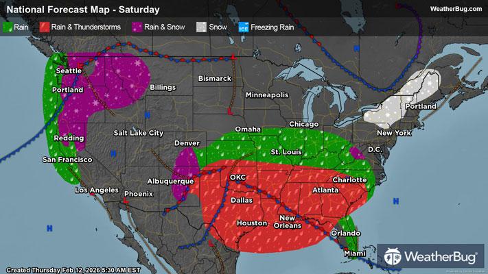
Saturday
In the Northeast, lingering moisture will sprinkle snow along the U.S.-Canada border from New York to New England. The remainder of the Northeast will be clear throughout the day on Saturday. In the Mid-Atlantic and Southeast, high pressure will allow for a romantic stroll outside, as conditions remain dry throughout the day.
There will be a sprinkle or two of some rain in the early morning hours of Saturday in southern Florida, but this rain should dry up shortly after sunrise, allowing for ample opportunities to celebrate Valentine’s Day outside. These light rain showers will return in the later evening hours, encompassing most of Florida.
For the Deep South, dry weather conditions are not spared, as Texas will begin the day on Saturday with rain and strong thunderstorms. This wet, unruly weather will shift eastward as the day progresses, dragging the stormy weather along the Gulf Coast.
The Midwest will also get a taste of this wet weather, as a low pressure system builds over the Plains throughout the day, bringing rain and thunderstorms to most of the Central Plains. The Northern Plains may see some rain showers from this low pressure system, but with the system shifting eastward, showers will mainly move to the lower Great Lakes Region all the way down through the Ohio River Valley and Tennessee Valley.
The Mountain West will be rather wet this Saturday, with valley rain and mountain snow in the Northern Rockies in Idaho and Montana, as well as in the Southern Rockies. Colorado and New Mexico should expect rainy conditions in the valleys and mountain snow until evening hours, meaning that loved ones may need to share an umbrella for the walk to Valentine’s Day dinner. However, this wet weather might offer some relief to skiers in the Denver metro with some fresh powder to celebrate with your partner!
Wet weather will come off the Pacific Ocean, bringing rainy conditions to Pacific Northwest Coasts and mountain snow to the Cascades this Saturday. This precipitation will inch its way down California throughout the day on Saturday, bringing snow to top the Sierra Nevada.
The Desert Southwest will enjoy another blissful Saturday with dry conditions, as people in this region do not have to worry about rain impacting their Valentine’s Day.
Luckily for the Nation, romantic outdoor strolls are made possible by the lack of single digit temperatures during the day this Saturday. Areas seeing sub-freezing temperatures will be the U.S.-Canada border in the Northeast, and the mountain peaks in the Rockies, Sierra Nevada, and the northern Cascades.
The 30s should be expected for the New England Coastline, Great Lakes region, and foothills of the Rockies. The remainder of the Northeast, lowland areas within the Rockies, and the Pacific Northwest will see 40s during their romantic outings.
Temperatures in the 50s will dominate the Mid-Atlantic, Ohio River Valley, Tennessee Valley, and Central Plains. Areas in the 60s will be the northern border of Southeastern and Deep South states, California’s Central Valley and the Desert Southwest.
The 70s are in store for most of the Southeast and Deep South this Saturday. High 70s will be present in southern Florida and southern Texas, while the Rio Grande Valley will be in the 80s!
Sunday
The Northeast will enjoy a dry morning, but some precipitation will inch its way into the area by afternoon, bringing a rain and snow mix. Snow will mainly stick to the Appalachians, while a mix will fall into the lowland areas. By late Sunday night, this rain and snow mix will have made its way up to the northern border of New York, inching into New England.
The Mid-Atlantic will wave goodbye to dry weather, as moisture from an incoming low pressure system will settle into the area, possibly bringing snow to parts of the Appalachians and rain elsewhere. As this low pressure system passes, there is a chance for some heavier bouts of rainfall associated with the chance for some isolated thunderstorms.
The Southeastern U.S. and Deep South will experience some wet weather this Sunday, as a low pressure system will primarily sweep over this portion of the country. As the cold front from this low pressure system passes through, thunderstorms and heavy rounds of rain will pass through the area. Texas will catch a bit of a break, as that area will have seen this weather in the latter hours of Saturday.
In the Midwest, rain will find itself clinging mostly to the southern Great Lakes into the Mississippi Valley. With rain exiting the Central Plains early Sunday, the passing of a low pressure system will allow for some dry weather relief for the much of the day. Because this rain is moving from west to east, that means the Ohio River Valley and Tennessee Valley will see rainy conditions throughout the entirety of Sunday.
The Mountain West will be mostly dry on Sunday, allowing for those who did not want to brace the slopes on Saturday to end the weekend with some tranquil skiing and snowboarding. The Northern Rockies will see a continuation of some valley rain and mountain snow, but this precipitation will remain in northern Idaho and Montana.
The Pacific Northwest does not seem to catch a break this weekend from rain and snow, as Sunday will bring similar mixed wintry conditions to the area. Mountain snow and valley rain will continue to fall in parts of the region down through California this Sunday.
With rain falling through California this Sunday, the Desert Southwest will be mostly dry, but southern Californians will not be pleased to see wet conditions damper the tail end of their weekend plans. Other than some rainfall in southwestern California, the Desert Southwest will have dry weather conditions on Sunday.
The temperature trend will be similar to Saturday this Sunday. Sub-freezing temperatures will be sparce, only present among the U.S.-Canada border in the Northeast, and the mountainous peaks of the Rockies, Cascades, and Sierra Nevada. Temperatures in the 30s are in store for the New England coastline and most of the Northeast, as well as the eastern Great Lakes region, the U.S.-Canada border in the northern Plains, and foothills of the Rockies.
Areas seeing 40s will be the Mid-Atlantic along the foothills of the Appalachians, the Ohio River Valley, the foothills of the Sierra Nevada and the Rockies, and the Pacific Northwest. Temperatures in the 50s will dominate again on Sunday for most of the Mid-Atlantic, the Tennessee Valley, the lowland areas in the Rockies, and California’s Central Valley.
Most of the Southeast, Deep South, Central Plains and Desert Southwest will see temperatures in the 60s and 70s, with southern Florida and southern Texas seeing high 70s. There will be a few areas in the Rio Grande Valley and southern Florida that hit the 80s on Sunday.