Back to All Alerts
Rain Eases Drought in West and South, Worsens in Northeast
October 31, 2025 at 12:57 AM EDT
By WeatherBug Sr. Meteorologist, James Aman

Heavy precipitation (over 3 inches) was observed last week from northern California to western Oregon and western Washington State. Above-normal rainfall was also seen in Idaho and western Montana. Farther east, 2-3 inches of rain doused numerous locations from Oklahoma southward to central Texas, and eastwards the lower Mississippi Valley, parts of the central Gulf Coast, Tennessee Valley, and much of northern Georgia and most of the Carolinas. Other small pockets of heavy rain impacted the east coast of Florida and some areas just downwind of Lake Erie. All these areas showed improvement.
In contrast, much of the Midwest, Ohio Valley, Mid-Atlantic and New England had below-normal rainfall. Other areas with below-normal rainfall during the past week were in southern Georgia, Nebraska and South Dakota, and across the Southwest U.S. Many of these areas reported deepening drought.
Northeast
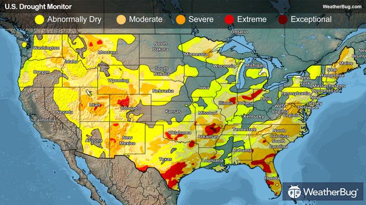
Several inches of precipitation fell downwind of Lake Erie (from just east of Cleveland to the Buffalo, N.Y., area), leading to improvements there. Elsewhere, light to moderate rain fell to the east of Lake Ontario and across parts of New England, with a few higher amounts observed in northern New Hampshire and eastern Maine. Over the rest of the Northeast Region, only scattered totals under 0.2 inch were recorded. Improvement was noted in western Pennsylvania, westernmost New York, some of the higher elevations in Vermont and New Hampshire, and part of eastern Maine. In contrast, below-normal precipitation resulted in deterioration in southern Maine, parts of interior Upstate New York, and small sections of southern New Jersey and Maryland. Several sites in the eastern parts of Maryland and Pennsylvania reported record or near-record low stream-flows for late October. Rain totals for the past 60 days are 3 to 6 inches below normal in a swath from Maryland and southern Pennsylvania through central and eastern Pennsylvania, northern and western New Jersey, Upstate and southeastern New York, and scattered areas across New England.
Southeast
Precipitation was highly variable across the Southeast Region. At least an inch fell on the central and southern Carolinas, central and northern Georgia and Alabama, the southern Florida Panhandle, and parts of the central and eastern Florida Peninsula. Over 3 inches doused western South Carolina and adjacent areas, isolated locations across northern Georgia, part of east-central Peninsular Florida, and coastal western Florida Panhandle. In contrast, little or no rain fell on most of Virginia, southern Georgia, southeastern Alabama, and most areas on the Florida Peninsula.
This resulted in widespread improvements from central South Carolina westward into the southern Appalachians and the northern and western sections of Alabama. Farther south, where rainfall was limited, a deepening drought was observed in southeast Alabama, part of southern Georgia, plus portions of the Florida Panhandle.
The most intense drought conditions now cover a broad swath across northern Florida and adjacent portions of southern Georgia, where D3 (extreme) drought conditions now dominate. Smaller areas of D3 cover west-central Alabama and northwestern Georgia. Severe drought (D2) is extant in surrounding areas plus southeastern Alabama, eastern North Carolina, and part of northern Virginia. The largest rainfall deficits over the past 60 days cover parts of the Virginia Blue Ridge, eastern North Carolina, and in some areas near the Florida/Georgia/Alabama borders. In these areas, rain deficits total 4 to 8 inches since late August.
South
Heavy rains in many areas led to broad areas of improvement across most of Texas, Oklahoma, Louisiana, Mississippi, and Tennessee. Several inches of rain resulted in a few swaths of 2-category improvement across central and east-central Texas as well as central Oklahoma, where upwards of 4 to 8 inches of precipitation were observed. In contrast, areas that missed the heavy rains saw deterioration, specifically southern and coastal Texas, part of the Texas Panhandle, and a few patches of the Red River (South) Valley. Despite the wet week, 90-day rainfall amounts ranged from 3 to 6 inches below normal across much of the Red River (South) Valley, and deficits of 4 to locally over 10 inches were noted from central Texas eastward along and near the Gulf Coast.
Midwest
Several inches of precipitation fell near Lake Erie, leading to a small area of 2-category improvement in northeastern Ohio. Moderate to heavy precipitation was reported across northern Upper Michigan, western Lower Michigan, northwestern Minnesota, southeastern Missouri, and areas near the confluence of the Mississippi and Ohio rivers. Other locations across Michigan, northern Minnesota, and the southern half of Missouri, and central through southern Kentucky observed light to locally heavy totals, while most areas from southern Minnesota, Iowa, and northern Missouri eastward across Illinois, Indiana, and Ohio experienced a dry week, with only isolated sites reporting up to 0.2 inch. Some of the wetter locations across Michigan and in the Ohio Valley saw improved conditions by the end of the week, and a few other patches of improvement were introduced based on a re-assessment of heavy rains earlier in the month. In contrast, a deepening drought was seen in portions of the dry swath from Iowa across Illinois into Indiana. Overall, the more intense conditions (D2 or worse) expanded slightly from 9.7 to 11.6 percent of the Region. Precipitation over the past 60 days was broadly 3 to 5 inches below normal in northern Wisconsin, part of northern and eastern Iowa, central and northern Illinois, and numerous locations across central Indiana and northwestern Ohio.
High Plains
The High Plains Region is currently the Region least affected by dryness and drought. Only 17 percent of the Region is affected by drought (D1-D4). Colorado and Wyoming are the most drought-impacted states, with about one-third of these two states experiencing some degree of drought (D1-D4), primarily in the higher elevations. In the Great Plains states, there is no drought in North Dakota. Dry conditions are a little more common farther south, with D0 or worse covering 39 percent of South Dakota, 35 percent of Nebraska, and 25 percent of Kansas. In all 3 states, drought (D1 or worse) coverage is less than 13 percent. Last week, moderate to locally heavy rain induced areas of improvement in eastern Kansas and far northwestern Wyoming, while patches of deterioration were introduced in eastern South Dakota and small parts of south-central Colorado and far northeastern Kansas.
West
Across the northern tier of the West Region, heavy precipitation led to improvements in a few areas, mostly across northern California, Oregon, and Washington, from the Cascades to the Pacific Coast. Many locations in the higher elevations of Washington and near the Washington and northern Oregon coastline measured over 3 inches of precipitation, with scattered amounts of 4 to locally over 8 inches recorded, particularly in northwestern and north-central Washington. Further east, recent precipitation led to some improvement across western Montana and northern Idaho. To the east, recent deficient precipitation totals led to deterioration across north-central Montana. Meanwhile, in the Southwest U.S., drought conditions generally persisted, with no changes made relative to last week across New Mexico, Arizona, Utah, Nevada, and most of California. Moderate to Extreme Drought (D1-D3) remains across southern California, almost all of Arizona, and much of New Mexico.
Looking Ahead
Over the next 5 days (October 30 – November 3), a large part of the Lower-48 is expecting little or no precipitation, specifically most areas from the Appalachians to the Pacific Coast. Light to moderate rain is forecast for most of interior New England, the central and southern Appalachians, the Oregon Cascades and Coast, the higher elevations of the Intermountain West, much of Peninsular Florida, and portions of the South Atlantic Coastal Plain. Heavier amounts exceeding 1.5 inches are anticipated across the Washington Cascades and Coast, isolated spots near the central and western Gulf Coast, much of the middle and upper Ohio Valley, most of a broad swath from Maryland through New York, and the Florida Keys. Daily high temperatures are forecast to average 2 to 4 degrees below normal across the Southeast, and near normal over the Northeast and the Lower Mississippi Valley. Unusual warmth featuring daily Highs of 4 degrees or more above normal is expected across the northern Great Plains and most locations from the High Plains to the Pacific Coast, outside the Pacific Northwest. Average daily highs could reach 10 to 14 degrees above normal across the eastern Great Basin and the central and northern Rockies.
During November 4 – 8, wetter than normal weather is again expected in the Pacific Northwest, expanding to cover the northern Intermountain West, western Great Basin, and central through northern California. Odds for wetness exceed 50 percent from northwestern California through central and western parts of Washington and Oregon. Elsewhere, wet weather is marginally favored in much of the South Atlantic, south-central and southeastern Alaska, and portions of northern Alaska. Meanwhile, most of a large swath from the Rockies to the Appalachians has enhanced odds for drier-than-normal conditions, with chances topping 50 percent across New Mexico and the western half of Texas. Subnormal precipitation is also marginally favored across all but the eastern fringe of the Big Island in Hawaii. Warmer-than-normal conditions are favored, from the Great Lakes and lower Ohio Valley through most areas from the Mississippi Valley to the Pacific Coast. Enhanced chances for warmer-than-normal weather also cover southern Florida, south-central and eastern Alaska, and Hawaii. Most areas over and near the central Rockies have chances for warmth exceeding 80 percent. Subnormal temperatures are only favored in New England and adjacent New York. In other areas, near normal temperatures are most likely.